


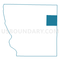
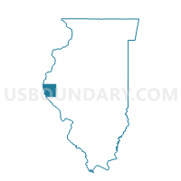
CLAYTON 1 Voting District, Adams County, Illinois
About
Outline

Summary
| Unique Area Identifier | 564512 |
| Name | CLAYTON 1 Voting District |
| County | Adams County |
| State | Illinois |
| Area (square miles) | 36.96 |
| Land Area (square miles) | 36.95 |
| Water Area (square miles) | 0.01 |
| % of Land Area | 99.97 |
| % of Water Area | 0.03 |
| Latitude of the Internal Point | 40.05994230 |
| Longtitude of the Internal Point | -90.97030570 |
Maps

Graphs
Select a template below for downloading or customizing gragh for CLAYTON 1 Voting District, Adams County, Illinois


Neighbors
Neighoring Voting District (by Name) Neighboring Voting District on the Map
- CAMP POINT 1 Voting District, Adams County, IL
- COLUMBUS 1 Voting District, Adams County, IL
- CONCORD 1 Voting District, Adams County, IL
- HOUSTON 1 Voting District, Adams County, IL
- HUNTSVILLE Voting District, Schuyler County, IL
- LEE Voting District, Brown County, IL
- NORTHEAST 1 Voting District, Adams County, IL
- PEA RIDGE Voting District, Brown County, IL
Top 10 Neighboring County Subdivision (by Population) Neighboring County Subdivision on the Map
- Camp Point township, Adams County, IL (1,632)
- Clayton township, Adams County, IL (1,027)
- Northeast township, Adams County, IL (840)
- Columbus township, Adams County, IL (551)
- Lee township, Brown County, IL (326)
- Concord township, Adams County, IL (287)
- Houston township, Adams County, IL (221)
- Pea Ridge township, Brown County, IL (188)
- Huntsville township, Schuyler County, IL (150)
Top 10 Neighboring Place (by Population) Neighboring Place on the Map
Top 10 Neighboring Unified School District (by Population) Neighboring Unified School District on the Map
- Brown County Community Unit School District 1, IL (6,926)
- Camp Point Community Unit School District 3, IL (5,029)
- Southeastern Community Unit School District 337, IL (3,209)
Top 10 Neighboring State Legislative District Lower Chamber (by Population) Neighboring State Legislative District Lower Chamber on the Map
Top 10 Neighboring State Legislative District Upper Chamber (by Population) Neighboring State Legislative District Upper Chamber on the Map
Top 10 Neighboring 111th Congressional District (by Population) Neighboring 111th Congressional District on the Map
Top 10 Neighboring Census Tract (by Population) Neighboring Census Tract on the Map
- Census Tract 103, Adams County, IL (5,890)
- Census Tract 102, Adams County, IL (3,720)
- Census Tract 9704, Brown County, IL (2,606)
- Census Tract 9701, Schuyler County, IL (2,256)